The Pay Roll MCX Claims include Tenure 1116849 (1 Cell) the Pay claim, and Tenure 1116854 (1 Cell) the Pay 2 claim both with GTD’s of October 21, 2026. The Pay Roll Minfile 082GSW037 has the occurrence located 1200 meters N/NW of the confluence of Wuho Creek and Moyie River. The occurrence is a vein-type deposit hosted by quartzites of the Helikian Middle Aldridge Formation (Purcell Supergroup). The Aldridge Formation quartzites are relatively flat-lying but with a gentle north dip. The deposit consists of individual, or zones of small quartz veins that crosscut the Aldridge Formation in a generally east direction and dip 65 to 75 degrees southwest. The veining is also associated with faulting in the area. A quartz vein in the order of 3 to 5cm wide is closely associated with a syenitic dike, and has visible free gold, pyrite, chalcopyrite, and a lead telluride mineral identified as altaite. Tourmaline has been identified in a vein in the southern part of the showing.
The Pay Roll (L.3562) and Paymaster (L.3561) were given crown grants in 1900. In 1907, M. Quaim mined 16 tonnes, which produced 715 grams of silver and 187 grams of gold (BC METAL MM00538). Reports states that gold values were in the order of 2 to 14 grams per tonne gold and 20.5 grams per tonne silver (Annual Report 1927, page 267).
Additional exploration included Cominco in 1982-1985 that completed programs of diamond drilling, which totalled 1157.8 metres in three holes, on the area as the Neg 1-3 claims (Assessment Reports 10603, 14724). And in 1988-1989 Ascot Resources Ltd. mapped and sampled the area (Assessment Report 26131). In 1992, 10 line-kilometres of combined electromagnetic, magnetic, and self-potential surveys was completed by Granite City Exploration (Assessment Report 22486). Super Group Holdings completed geological mapping in the area in 2000 (Assessment Reports 26480, 26724).
In 2013/2014, PJX Resources Inc completed a large program of gravity and magnetic geophysical surveying to detect dense subsurface features (Assessment Reports 34082, 34937, 35416). The gravity survey extended 10 kilometres beyond the West Basin property claim boundaries and encompassed several MINFILE occurrences which included the Pay Roll occurrence (Figure 8, Assessment Report 34082).
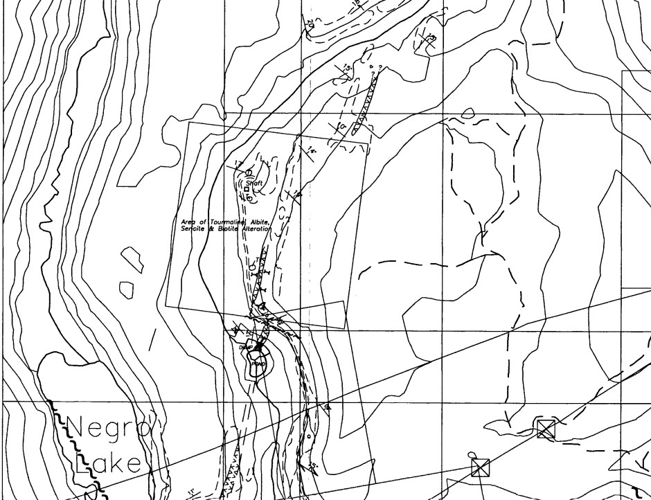
In ARIS 26131 about 400 meters northeast of Negro Lake and immediately west of the gabbro dike on the DA Vent property there is local development of vent-related alteration, including tourmalinization, albitization, sericite and biotite. The alteration is evident on surface over a north-south strike length of about 250 meters.
This alteration occurs in the immediate vicinity of a series of quartz veins, some of which are reported to carry gold mineralization. A number of old adits and a shaft are developed in this area of quartz veining and vent alteration. The old workings tested what appears to be two separate styles of quartz veining; a flat-lying set which consists of a few larger quartz veins, up to 1.5 meters thick, and a more complex suite of steep-dipping, thinner veins that are rarely as thick as 20 cm. The tourmalinization, albitization and sericite are closely associated with the steeply dipping quartz veins.
Two southern adits on the trail north from the Negro Creek bridge are developed on and under a northeast striking, shallow to moderately SE dipping (068/25 SE), milky white, rusty quartz vein that is up to 1.5 meters thick where it can be seen. The quartz vein carries pyrite, chalcopyrite and galena (with reports of visible gold). Both adits are actually dug on a brown-orange ‘dolomitic weathering’ carbonate-rich weakly pyritic felsic intrusive which underlies the quartz vein in the two adits and apparently is a dike paralleling the quartz vein. Most of the dump waste rock is of intrusive material and this may have been mined because it carries gold values. Another possibility is that the intrusive was mined preferential to the quartz vein because of its softer and fractured nature, simply to gain access to the overlying quarz vein for further testing.
North of these two adits, the trail leads to another three adits and one shaft / adit complex which are developed in separate occurrences of discontinuous, generally narrow light gray quartz veins. These occur as discrete veins and local quartz vein swarms. These quartz veins are within an albite-tourmaline & sericite alteration zone that is spatially (and possibly genetically) related to a NNE striking gabbro dike. The dike occurs immediately east of the alteration. Tourmaline in particular appears preferentially developed within some beds immediately adjacent to the quartz veins. There is also local lensey to vein-like development of coarse biotite or phlogopite which weathers rusty; these micas are probably also related to the venting process. The light gray quartz veins are NW oriented and may be an orthogonally-developed feature to the main NNE structure which is represented by the gabbro dike.
One adit is collered in a small, locally developed, disrupted ‘fragmental’ zone of broken and folded beds which are also albitized.
Near the southernmost adits, the gabbro dike is offset about 10-15 meters in a left lateral manner, along a possible NW striking fault.
Another adit is below the trail, immediately north of the small pond that is in the valley bottom at the south end of most of the adits. This adit starts in the gabbro dike and trends northeast. It appears to be one of the larger workings, judging from the size of the dump. The surface material on the dump is mostly sedimentary rock so development was within the gabbro for only a short distance. Considerable fine disseminated chalcopyrite and pyrrhotite are present in some of the dump material but there is no quartz vein material and it is not readily evident why this adit was driven.
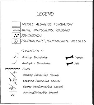
As the map below from ARIS 26131 shows there are 5 adits, 1 shaft, and 3 trenches outlined on the Pay Roll Crown Grant.
ASKING: Buyout or Option
