The George MCX Claim; Tenure 1122541 (1 Cell), GTD: 2026/Mar/24.
The George occurrence is Located 500 metres east of the Tangier River and about 250 metres north of its confluence with Moloch Creek, roughly 50 kilometres northeast of Revelstoke.
Lower Cambrian dull grey, flaggy crystalline limestone with slaty intercalations strikes at 345 degrees and dips 30 to 50 degrees east. Irregular lenticular quartz-calcite veins, up to 20 centimetres wide, disect the limestone and are mineralized including pyrite, sphalerite and galena. A mineral, thought to be tetrahedrite in the field, but resembles boulangerite under the microscope (Geological Survey of Canada Summary Report 1928 Part A, page 191).
In the period 1896 to 1898, the vein was stripped for 60 metres and an adit was driven 48 metres to cut the vein at depth. A winze, of unknown depth was sunk from the adit. These workings were badly caved when examined back in 1928. In 1899, a 3.6-tonne shipment of selected ore was sent to the smelter at Trail for testing and yielded “satisfactory” assays in all of gold, silver and copper. Then in August 1903, 5.5 tons was shipped to the Trail smelter and gave returns of $110 per ton. And in November of the same year, 2.5 tons was sent to Tacoma and produced returns of $116 per ton, mainly in silver respectively (Geological Survey of Canada Summary Report 1928 Part A, page 191).
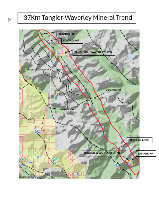
The George claim is one of 6 MCX Claims that runs for 37 Kilometers on a NW/SE Trend. The claims from NW to SE includes; Waverley-Tangier N2, the Waverley-Tangier N1, the Tangier-Waverley, the George, the Lanark, and the Dorthy MCX claims. The Map below outlines this trend.
ASKING: Buyout or Option
