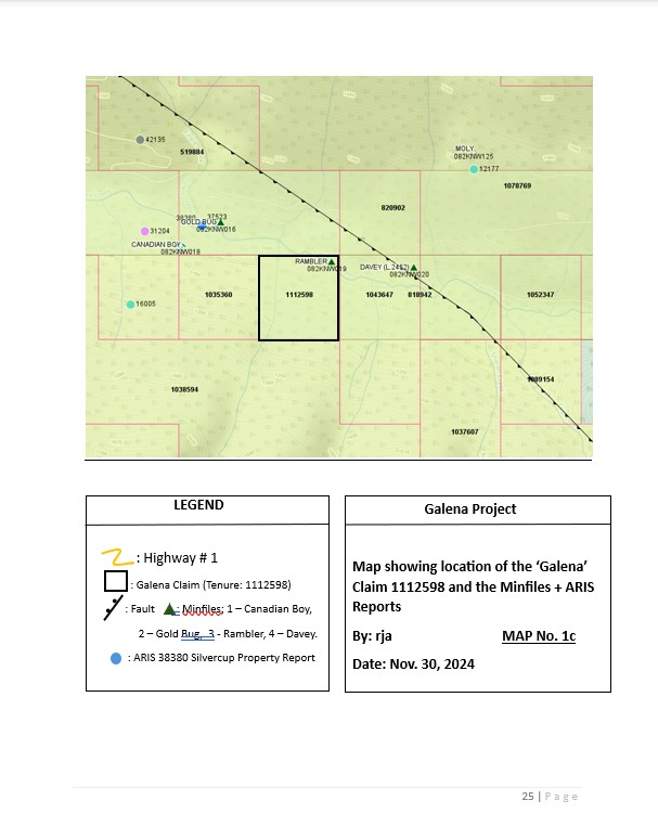
Galena MCX Claim; 21 Cells including; Tenure 1112598 (1 Cell), GTD: 2034/Jun/28. There are 4 Minfiles in the vicinity of the Galena Claim which include the: The Rambler, Gold Bug, Canadian Boy, Davey, and Moly (See Map 1c).
For the Rambler MF the area is underlain by black siliceous argillites and phyllites of the Triune Formation, Ajax Formation quartzite and black siliceous argillites and cherts of the Sharon Creek Formation. The rocks are isoclinally folded, highly deformed and locally intensely phyllitic. The rocks are on the northeast limb of the Silver Cup anticline and they strike to the northwest and dip at a moderate to steep angle to the northeast. On the Rambler claim, a band of quartzite, which is said to be the continuation of so-called “Nettie L. (a.k.a. Ajax) dyke”, crosses the creek and there are several showings of quartz carrying small amounts of galena, sphalerite, pyrite and a little chalcopyrite in schist adjacent to the contact. There is no major vein exposed. Messrs. Hladinec and Bobicki drove a diversion tunnel and used the old adit to reroute the creek. They then dammed the natural channel as part of a plan to extract placer gold from sand and gravel in a plunge pool. A small cut in the quartzite unit to the south of the old adit portal exposed several galena stringers that are up to 0.1 metre wide and approximately 0.30 to 0.61 metre apart. There are also similar galena-bearing veinlets in quartzite in the diversion tunnel.
For the Gold Bug MF the area is underlain by black siliceous argillites and phyllites of the Triune Formation, Ajax Formation quartzite and black siliceous argillites and cherts of the Sharon Creek Formation. The rocks are isoclinally folded, highly deformed and locally intensely phyllitic. The rocks on the northeast limb of the Silver Cup anticline. They strike to the northwest and dip at a moderate to steep angle to the northeast. The workings are at creek level. In 1917, Mr. Livingstone drove 58 metres of crosscut through a band of massive slate and drifted for 30 metres along a quartz vein with an apparent northwest strike. The vein was deformed and crushed, and composed of a mixture of quartz, crushed slate and galena, pyrite and sphalerite. It contained pockets of high grade galena. A sample across 0.08 metres assayed 0.68 grams per tonne gold, 2468 grams per tonne silver, 57.5 per cent lead and 8 per cent zinc. The 1917 report also states that there is low-grade mineralization on the Rambler claim [082KNW019], approximately 610 metres east of the Gold Bug workings.
A 0.5 metre wide sample of the ribbon-quartz vein adjacent to the graphitic shear zone, which strikes 170 degrees and dip 60-70 degrees to the east assayed 0.86 grams per tonne gold, 882 grams per tonne silver, 1.82 per cent zinc and 25.03 per cent lead. Mapping suggests that the mineralized veins plunge eastward. A report filed in 1993 (EMPR ASS RPT 22681) shows that Nortran Resources Limited diamond drilled and intersected stockwork mineralization; including a 0.75 metre section which assayed 1.30 grams per tonne gold, 82.3 grams per tonne silver and 4.4 per cent combined base metals. Step outs from this intercept did not encounter anything significant.
The best showing at the Canadian Boy MF was; By 1911, the drift had yet to reach the projection of the shaft but it was in “good” silver-lead ore estimated to average “$90/ton”. The vein was 1.2 metres wide in the tunnel and had a streak of decomposed material containing iron oxide with occasional bunches of solid galena on its hanging wall side. A sample taken across the vein assayed a trace gold and 54.8 grams per tonne silver. There was no assay for lead. A selected sample of galena from the drift assayed gold 1.37 grams per tonne gold, 2180 grams per tonne silver and 72.6 per cent lead. There is a large amount of pyrite associated with the galena and a clean pyrite sample assayed 15.77 grams per tonne gold and 226.3 grams per tonne silver.
Then later on where the property is reported to have produced 67 tonnes containing 6812 grams of silver, 230 grams of gold, 1485 kilograms of lead and 1282 kilograms of zinc in 1980. This production is not well documented. In 1987, L. B. York collected a “grab” sample from the winze area that assayed 3.43 grams per tonne gold, 2571 grams per tonne silver and over 50 per cent lead. His main target was described as being a 1.52 metres wide quartz vein that strikes to the southwest from the footwall of a large vein system that links the Silver Cup [082KNW027] to the Nettie L. [082KNW100] deposits.
The Davey MF reported; The Davey and associated claims are underlain by undifferentiated Lardeau Group strata on strike midway between the Nettie L. [082KNW100] and Silver Cup [082KNW027] deposits. They are folded, faulted and locally highly phyllitic.
There are three quartz veins on the Cheyenne claim. The south vein is 2.4 metres wide and open on strike. It has 0.15 metre of galena ore on its hanging wall and is cut by several small stringers of galena. There is a short adit on the centre vein, which shows a little galena mixed with quartz. The Coon claim has two veins that have been traced for several tens of metres. A crosscut taps the main vein at a depth of 7 metres. At this point, it is 1.8 metres wide and carries about 0.08 metre of solid galena in its hanging wall. An open cut on the south vein exposes a large body of quartz that contains specks and small seams of galena. The Davey vein was exposed by an open cut and a 10.6 metres long tunnel. There is a small amount of mineralization on its hanging wall.
The Moly MF has; The Moly claim area is underlain by folded and deformed phyllites and grits of the Broadview Formation; however, the detailed geology of the area is poorly defined. Moly Gold Resources Limited located a strong gossan and diamond drilled one hole, for 20.11 metres, to test the occurrence. It intersected 2.59 metres of mineralized siliceous phyllite near a contact between phyllite and tuffaceous rock. The mineralized section included at least three quartz brecciated phyllite horizons, ranging from 0.03 to 0.46 metre in width, containing disseminated to semi-massive pyrite, sphalerite and galena. The best core section assayed 5.07 grams per tonne gold, 473 grams per tonne silver, 5.6 per cent lead and 2.56 per cent zinc over 0.21 metre.
This author believes that the mineral occurence of the Rambler MF, is a band of quartzite, which is said to be the continuation of so-called “Nettie L. (a.k.a. Ajax) dyke”, crosses the creek and there are several showings of quartz carrying small amounts of galena, sphalerite, pyrite and a little chalcopyrite in schist adjacent to the contact. And this same occurence could be part many other showings/mines on the Silver Cup Ridge Trend.
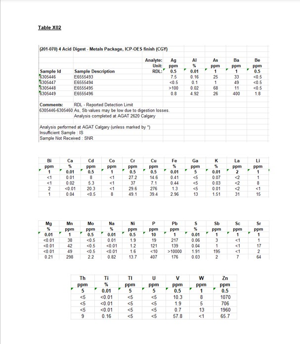
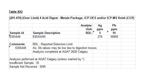
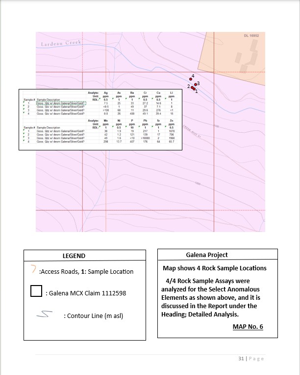
Also attached below are inhouse multi-element Assays, Overlimit Assay Table, and Map 7 with the sample locations and Assay Results outlined on the map.
ASKING: Buyout or Option