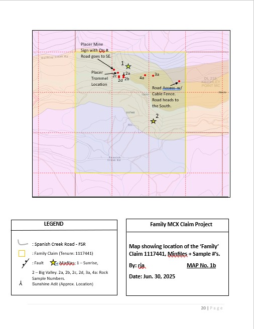
Family Claim MCX Claim; 9 Cells including; Tenure 1117441 (9 cells). Two Minfiles on the claim include the Sunshine, and the Big Valley (See Map 1b). In summary the Sunshine MF the area is within the Quesnel terrane of the Intermontane Belt near its eastern margin, adjaceant to the Precambrian to Paleozoic rocks of the Omineca terrane. The main lithologies consist of red brown weathering phyllite,grey siltstone, and interbedded felsic tuffs, which form the lowermost part of the Upper Triassic to Lower Jurassic Nicola Group. Formerly referred to as the “Black Phyllite” this unit has been thrust onto the older Omineca terrane rocks, and as a result have been deformed and metamorphosed, likely during Middle to Late Jurassic time to . Locally, an adit, known as the Sunshine adit, that is caved or collapsed, exposes a northwest striking quartz vein hosted in a schistose argillite. The vein is approx. 3.6 metres wide and hosts irregular galena mineralization. A selected sample across a 3.5 metre section was assayed at 27.4 grams per tonne gold (Energy Mines and Petroleum Resources Annual Report 1933, p. A136) See Map 7. In 1987, another sample (685) from a small quartz vein, did assay 0.45 gram per tonne gold, 267.7 grams per tonne silver, 4.04 per cent lead and 4.45 per cent zinc (Assessment Report 17103). Another occurence located 100m downstream of the adit is comprised of a 30 by 30m area of pulaskite hosting quartz-carbonate stringers with sparse galena. A select sample assayed 41.4gpt Ag (ARIS 9916). Additional work included regional prospecting and sampling by Keweenaw Syndicate in 1967. During 1981 through 1984, Apex Energy completed programs of airborne and ground geophysical surveys, prospecting, geological mapping and soil sampling on the area as the Nov 1-3 claims. During 1984 through 1986, Mt. Calvery Resources completed programs of geological mapping, prospecting, trenching and geochemical sampling on the area. In 1987, Malcom Resources completed a program of soil sampling, prospecting and trenching on the area.
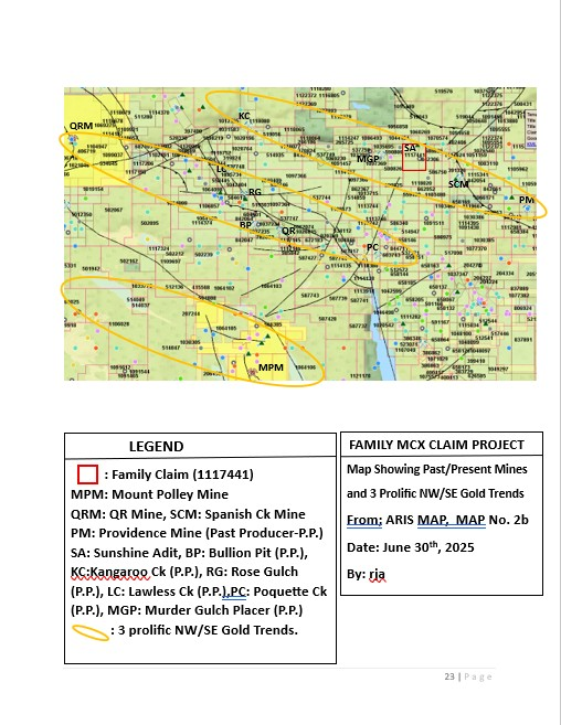
The Big Valley Minfile showing is approx. 2Km west of its’ confluence with Spanish Creek (See Map 2b). Geology is the same as described above in the Sunshine MF. Locally, a black phyllite and/or schistose argillite hosts a zone of phyllic-kaolinitic alteration over 40 metres in length with oxidized quartz veins. The veins vary from 0.2 to 5.0 metres in width. Mineralization consists of disseminated to massive galena mineralization. In 1987, a sample (638) assayed 3.35 grams per tonne gold, 339 grams per tonne silver, 18.90 per cent lead and 26.60 per cent zinc (Assessment Report 17103). In addition to the similar work described above in the Sunshine MF, in 2019 and 2020, KORE Mining Ltd. completed programs of prospecting and geochemical (rock and soil) sampling on the area as part of the South Cariboo property.
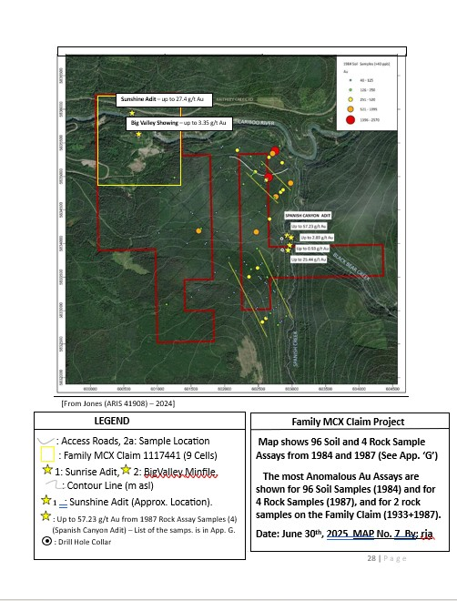
This author believes that the mineral occurence at the Family MCX claim (See Map 2b) is likely an extension of the Spanish Canyon occurence, located as close as 2.2Km SE of the Big Valley Minfile, and the Murderer’s Gulch MF located 2Km NW of the Big Valley MF. And the presence of the adit samples, and drill intercepts recorded in the Spanish Canyon Minfile is evidence of the later statement. In 1981, a sample from a 10 centimetre vein, located between the two adits, assayed 6.9 grams per tonne gold and 49.6 grams per tonne silver (Assessment Report 9916). The following year, a diamond drill hole (DDH 82-1) intercepted a mineralized quartz vein at 64.64 metres depth and yielded 0.53 grams per tonne gold, 5.0 grams per tonne silver and 0.072 per cent lead over 1.35 metres (Assessment Report 10812). And in 1987, a 0.91 kilogram grab sample (691) of convergent quartz veins containing pyrite, galena and limonite from an adit on the Nov 2 claim assayed 28.04 grams per tonne gold, 151.86 grams per tonne silver and 2.8 per cent lead (Property File – Malcolm Resources Ltd. Mar. 14, 1988 Prospectus).
ASKING: Buyout or Option