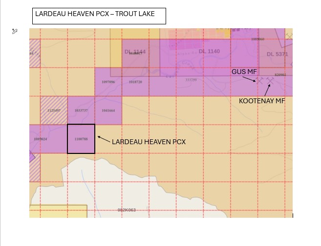
The Lardeau Heaven Tenure 1100788 (1 cell) Expires 2034/Oct/06. The prolific Lardeau Creek has produced gold for over a hundred years including from fine grained to nugget and larger sized gold. The closest Minfiles are the Gus MF and Kootenay MF located 3.0 and 3.2Km NE upstream of the Lardeau Heaven PCX claim respectively.
In the Gus MF it states; the geology of the area is poorly defined. However, it is underlain by folded and deformed phyllites and schists of the Lardeau Group. In 1984, Moly Gold Resources Limited drilled a single diamond drill hole to test for mineralization reported in a nearby, caved adit. The hole returned intersections of siliceous phyllite and meta-argillite containing numerous barren quartz veinlets and sweats with 1-2 percent pyrite, and a 0.06 metre wide zone containing semi-massive pyrite, galena and sphalerite. The mineralized section assayed 10.59 grams per tonne gold, 103 grams per tonne silver, 1.58 per cent lead and 1.98 per cent zinc over 1.83 metres. The adit was in the eastern part of the Gus #1 claim, and may have been on the old Bell Boy (L.7442) claim. It had been driven to the north into the hill.
For the Kootenay MF; The Kootenay claim area is underlain by isoclinally folded and variably schistose siliceous argillite of the Triune Formation, quartzite of the Ajax Formation and siliceous argillite of the overlying Sharon Creek Formation. The rocks strike to the northwest and dip moderately to steeply to the southwest. Westmin Resources identified a silver-in-soil geochemical anomaly in the area in 1982 and Camfrey Resources Limited delineated it in the late 1980s. The company trenched and diamond drilled the area in 1987. In doing so, it located several previously unmapped bedding plane parallel and cross cutting faults that localize irregular lenses and stringers of quartz mineralized with galena, sphalerite, pyrite and chalcopyrite. The most significant mineralization was encountered in a 5 to 15 metres wide zone of fracturing along a contact between quartzite and argillite. The zone extends for 100 metres along strike and displays two principal jointing directions, both of which are filled with narrow (0.2 to 2.5 centimetres wide) quartz-siderite stringers that contain coarse-grained sulphides. One drill intercept assayed 0.69 grams per tonne gold, 92.4 grams per tonne silver, 0.57 per cent zinc and 0.80 per cent lead over 1.52 metres.
Most motherlode deposits are generally located within 5Km of good placer gold. The Gus and Kootenay MF’s report up to 10.59gpt Au, and 103gpt Ag, 1.58% Pb, and 1.98% Zn over a 1.83m drill intercept, located upstream 3.6-4.0Km, and south of the Lardeau Creek approx. 300m.
ASKING: Buyout or Option
